Nepal flood- When the mountain fell: The warning no one could read in time
August 26th, 2026 began like any other morning along the Trishuli River — until, without a monsoon downpour, without a forecast, without any conventional
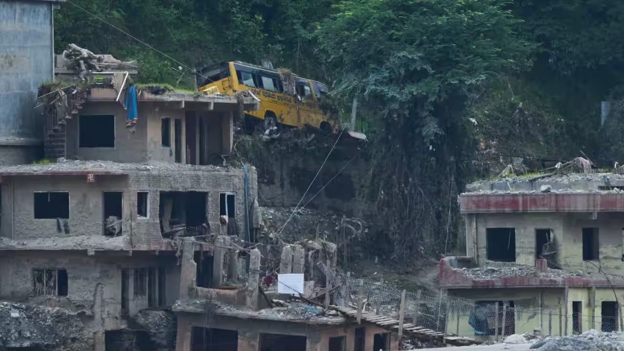
August 26th, 2026 began like any other morning along the Trishuli River — until, without a monsoon downpour, without a forecast, without any conventional trigger at all, a mountain gave way. High on the Nepal-China border in Rasuwa district, a mass of ice and rock sheared off and plunged into the Bhote Koshi–Trishuli corridor. Within thirty minutes, according to a report shared by ICIMOD, water levels on the Trishuli River had risen by as much as nine metres. The surge tore through the Gyirong Port on the China-Nepal frontier and struck dozens of settlements along a 72-kilometre stretch of river, choking hydropower intakes with debris, jamming tunnels that were the economic lifeline of the valley, and leaving thousands of lives unaccounted for.By UN Nepal's Situation Report 8 (15 September), the toll stood at 1,399 confirmed dead, 5,179 still missing, and 13,742 rescued. NDRRMA's(National Disaster Risk Reduction and Management Authority) Rapid Damage and Needs Assessment recorded 7,570 damaged buildings — concentrated in Nuwakot — alongside 41 bridges washed away entirely, 15 hydropower projects damaged across Rasuwa and Nuwakot (including 93 workers missing at Rasuwagadhi alone), and only 3 of the three districts' schools left standing safely enough for students to return. Roads, water systems, health posts and government offices across Rasuwa, Nuwakot and Dhading remain disrupted, and that damage isn't incidental to the response — it is actively constraining humanitarian access to the hardest-hit, hardest-to-reach villages even now.The scale of loss is the story everyone has already told. The more consequential story — is what happened, or failed to happen, in the hours and weeks before the mountain fell: what the satellites could see, what the institutions could act on, and where the gap between the two turned a geological event into a mass-casualty disaster.The warning that arrived too quietlyIt turns out the mountain had been moving for months. A Nature News Q&A (2 September 2026) reported that analysis of European Space Agency Sentinel-1 radar data (a collection of high-resolution, all-weather, day-and-night images of the Earth's surface), covering 8 January through 18 August 2026, found the glacier-rock mass creeping downhill at roughly 10 millimetres per month in the weeks before collapse. In hindsight, that is a signature: a slope in the final stages of failure. In real time, it was almost useless.That gap is the crux of the problem. Ten millimetres of monthly creep is the kind of signal that shows up clearly in a retrospective satellite time series and almost nowhere in an operational early-warning workflow — existing monitoring techniques still struggle to convert "acceleration" into an actionable, dated forecast of imminent failure.The instability sat directly on, or near, the Nepal-Tibet border, in terrain where effective early warning depends on rapid, routine observation-sharing between the two countries — sharing that, by every account of this event, did not functionally exist. So even where the data existed, the institutional pipeline to turn it into a downstream evacuation order may not exist. This is worth noting, because it reframes the disaster: not as an unforeseeable act of nature, but as a hazard that was partially visible, moving through a governance and monitoring architecture that had no mechanism to translate visibility into warning.A mountain that had been warming for decadesThe climate dimension of the story is easy to narrate and just as easily dismissed too quickly — the real picture sits in between. Data compiled and analysed by “The Climate Brink”( shows that summer temperatures at the collapse site have warmed by around 0.29°C per decade since 1940, with the most recent thirty years (1996–2025) running roughly 1°C above the 1961–1990 baseline. The four most recent summers — 2022 through 2025 — all rank among the five warmest on record at the site. The collapse came at the tail of an exceptionally hot stretch: July 2026 was the second-warmest in an 86-year record, and the first three weeks of August ran hotter than any complete August ever recorded there, before the mountain gave way on the 26th.None of this means a warm summer, by itself, brings a mountain down. What sustained warmth does is quieter and more structural: it melts the ice that buttresses steep slopes, sends meltwater into rock fractures, and degrades the permafrost(any ground that remains completely frozen — 32°F (0°C) or colder — for at least two years straight). That acts as a frozen adhesive holding fractured high-altitude rock together. Layer onto that a longer-term signal — regional glacier mass balance has been declining for decades, with estimates putting cumulative ice-area loss in this catchment above 40% — and you have a slope that has been losing its structural support system incrementally for years, even if no single year "caused" the collapse.So can this event be attributed to climate change? The thinning of Himalayan ice is not new, and hazard from these slopes is driven less by “how much” ice sits on them than by “how fast” the ice and the frozen ground beneath it are changing. A cold glacier frozen stably to its bed is comparatively secure; one in active transition — warming, thinning, losing its permafrost cement — is not. What can be said with confidence is that the mountain failed inside a climate trend, not despite one: temperatures at the site are rising, the glacier's structural support is eroding, and that combination is precisely the kind of long-run vulnerability that turns an otherwise geologically plausible event into a more probable one. Formal attribution of this single collapse to climate change would require the kind of detailed forensic reconstruction that, for comparable events like the 2021 Chamoli disaster, took scientists a year or more to complete — so any confident claim in either direction, made this soon, should be treated with some scepticism.The question that should outlast the news cycleStrip away the individual numbers and a pattern emerges that should matter more to policymakers than any single death toll: a partially observable hazard, on a slope that had been destabilising for decades, in a transboundary zone with no functioning mechanism to convert satellite data into a warning a villager downstream could act on. That is not a story about an unpredictable mountain. It is a story about the distance between what modern remote sensing can see and what modern institutions are built to do with it — and about how that distance, in this case, was measured in over a thousand lives. The rebuilding conversation in Nepal will inevitably center on roads, bridges and hydropower. It should. But the harder, less visible reconstruction task is the one this event has exposed most starkly: an early-warning architecture that can survive a border, act on a ten-millimetre-a-month signal, and reach a valley faster than a flood can travel through it.What Comes Next: The scale of this disaster means the response cannot be sequential — search and rescue, relief, and reconstruction planning have to run in parallel, each on its own clock.Immediate: With 5,179 people still unaccounted for as of the 15 September situation report, search and rescue cannot be allowed to wind down on the same timeline as the media cycle. Every day that passes narrows the odds of finding survivors, but it does not reduce the humanitarian obligation to find the dead.Immediate to short-term: Stabilising livelihoods·Cash compensation to affected families should follow quickly, and it should be understood for what it is and isn't. It will not offset a life lost or a home destroyed — no transfer does that — but it buys families the one thing a disaster strips away first: the ability to make near-term decisions (food, temporary shelter, transport, medicine) without going into debt to do it.·Alongside cash relief, near-zero-interest soft loans from nationalised banks, disbursed on an expedited basis to residents of the affected districts, would let households restart the smaller economic activities — shops, farming inputs, transport, small trades — that a lump-sum grant alone can't fully restore.Short-term: ·Reconstruction of the 41 washed-out bridges, repair of damaged roads and transport links, and desilting of the Trishuli and its tributaries should begin as soon as safety assessments allow, both because isolated villages need physical reconnection and because a silted, debris-choked riverbed raises the flood risk for the next monsoon before the region has even recovered from this one.Medium to long-term: Financing The World Bank, Asian Development Bank, and JICA all have existing disaster-recovery and resilient-infrastructure financing instruments suited to exactly this kind of multi-sector reconstruction. "Build back better" has to mean something concrete here — hydropower and settlements re-sited or re-engineered with a wider margin from the riverbank, construction standards that account for debris-flow and flash-flood loading rather than just seismic loading, and coordination across the many stakeholders (government ministries, donors, local governments, communities.An early-warning system that actually worksClosing that gap requires two things operating together, not separately: formal, routine institution-to-institution data-sharing across the Nepal-China border, so that monitoring doesn't stop at a national boundary the hazard itself ignores; and active community-level participation in the last mile of that system, so that a warning issued in a monitoring center actually becomes an evacuation on the ground in time to matter.Disclaimer: Views expressed above are the author's own.
Topics in this story
Gathered from external sources. Rights to this text belong to whoever originally published it.