In 2005, a California engineer used Google Earth to challenge a logging plan above Los Gatos Creek; community pressure later helped spare 1,000 acres of redwood watershed
US News: In 2005, residents of the Santa Cruz Mountains utilized Google Earth to successfully combat a logging plan proposed by San Jose Water Company, saving 1,000 acres of redwood watershed. Discover the impact of technology in environmental activism and the community's journey against corporate development.
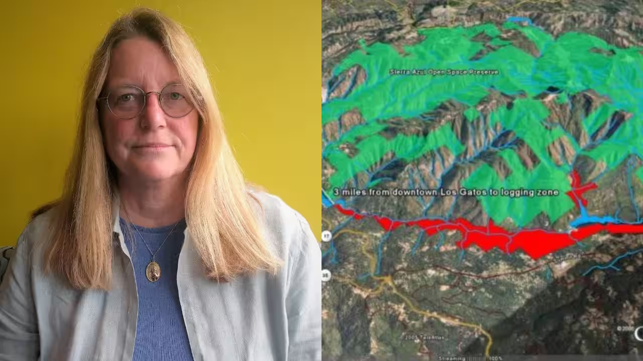
Residents who oppose corporate development plans frequently find it difficult to understand complicated legal notifications and technical maps that unexpectedly arrive in the mail. When a group of landowners in the Santa Cruz Mountains of California got an official notification in 2005 detailing a proposal to chop a sizable area of forest above their homes, they found themselves in precisely that predicament. What transpired became one of the first instances of ordinary people using digital mapping technology to oppose a powerful organisation and alter the course of a local environmental battle.The warning was from the San Jose Water Company, a company that owns about 6,000 acres in the Los Gatos Creek watershed, a source of drinking water for more than 100,000 people in Silicon Valley. The company submitted a plan in August 2005 to cut about 1,000 acres of forest including coast redwoods and Douglas fir along a six-mile section of canyon, and copies of a black and white map explaining the plan were mailed to neighbouring people. For many, the document was almost impossible to comprehend as it gave little differentiation between roads, contour lines and the real borders of the proposed logging zone.Making sense of the mapOne of the residents to get the warning was engineer Rebecca Moore, who was working on a mapping tool within Google that would become known as Google Earth Outreach. Instead of relying on the confused paper map, Moore set out to make her own map using satellite imagery and aerial pictures of the entire watershed. She helped create a neighbourhood group, Neighbours Against Irresponsible Logging, and utilised the new Google Earth software to map the proposed logging area much more accurately than the utility’s initial document had done.Moore’s computer map did more than map out boundaries. She layered in geo-located photographs of old-growth redwoods that stood in the way of the plan, added sightings of local wildlife such as ospreys and beavers, and imported data that showed that endangered red-legged frogs lived in the canyon, directly contradicting the company’s claim that no protected species were present. She also teamed with a colleague to build a three-dimensional flypast of a simulated helicopter carrying cut redwood trunks on a flight path over nearby schools and residences.The evidence offeredMoore’s presentation of her flypast at the group’s inaugural community gathering had an instant impact. Residents who had failed to interpret a flat printed map could suddenly see, in three dimensions, how narrow mountain roads laced with more than 30 blind curves would convey a dozen 90,000-pound logging trucks each day past pathways frequented by children heading to school. The presentation gave the community a common and correct picture of exactly what the logging plan would do for their neighbourhood, which the initial notification had not provided.Separately, opponents of the plan objected to the size of the company’s assets. Residents said their own aerial surveys showed the company’s actual holdings exceeded a ceiling set by California law on the amount of commercially harvestable forest a single owner could hold and still qualify for the kind of open-ended logging permit the water company wanted. The issue was sent to California’s forestry regulator, which has standards for assessing proposals like these established by the CAL FIRE Board of Forestry and Fire Protection.A campaign that made a differenceEventually community pressure and more regulatory issues pushed a turning point. By December 2007, almost two years after the original notice was mailed, the water company had withdrawn its logging proposal, and California’s forestry department had found the plan invalid under the laws that governed it. The result, for the redwood watershed above Los Gatos, was that some 1,000 acres of forest were saved from the large-scale cutting which the original plan had called for.The episode also had repercussions well beyond a small canyon in California. Moore’s success in using Google Earth to expose the difference between a company’s official map and the actual size of its plans became one of the origin stories for Google Earth Outreach, a programme designed specifically to help environmental and community groups use mapping technology in their own campaigns. Moore has said the fight above Los Gatos Creek influenced her later work creating tools to detect deforestation and environmental change across continents.Today, San Jose Water owns and manages thousands of acres in the same watershed and describes its approach to the property in terms of long-term stewardship rather than massive-scale timber harvesting. The 2005 controversy is one of the most startling early examples of how accessible digital mapping can shift the power from major institutions to locals, changing what may have been an intractable bureaucratic war into a contest that ordinary people could see clearly enough to win.Catch the latest World News and Live updates. Download the TOI app.
Topics in this story
Gathered from external sources. Rights to this text belong to whoever originally published it.