In 2007, a Kazakh economist searching Google Earth for pyramids found giant crosses and rings; dating points to about 800 BC
Rest of World News: In 2007, a Kazakh economist discovered immense geometric earthworks in northern Kazakhstan using Google Earth, dating back to 800 BC. These structures, resembling crosses and rings, have sparked significant archaeological interest, but their exact purpose remains a mystery. Explore the story behind these ancient geoglyphs.
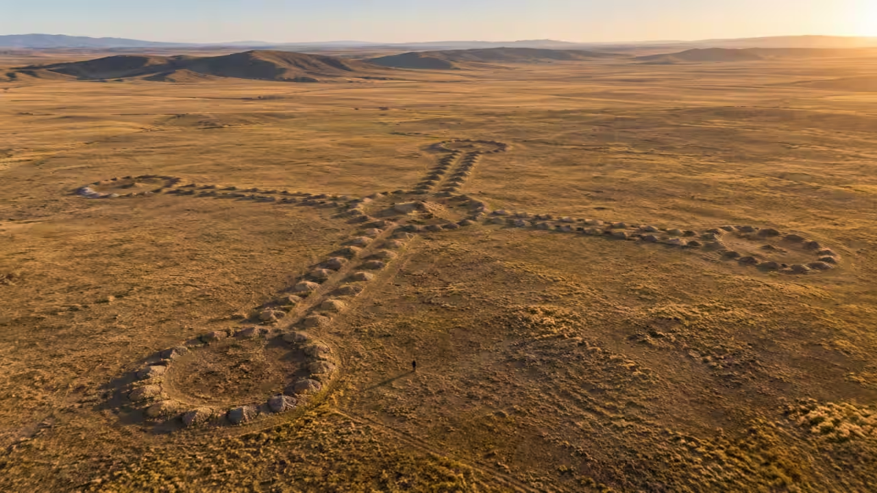
Dmitriy Dey was looking for pyramids when Google Earth led him to enormous geometric earthworks that were spread across the Turgai steppe in northern Kazakhstan. Dey is a Kazakh economist and archaeology enthusiast, who spotted structures that formed squares, crosses, rings and other shapes across the landscape in 2007. The largest were hundreds of meters wide and difficult to recognize from the ground, and the discovery eventually drew archaeologists, satellite researchers and NASA's attention to a group of earthworks that had gone unnoticed. Dey's own Turgay Discovery project says that he found the first geoglyphs while studying satellite images of the region in 2007.Live Science reported in 2014 that more than 50 geoglyphs had been identified across northern Kazakhstan, with individual structures ranging from about 90 to 400 meters across, which were formed mainly from earthen mounds arranged into geometric patterns. Archaeological work later found structures and hearths at some sites, although researchers said their exact purpose remained uncertain. Some possibilities included ritual activity or marking territory, but the evidence did not establish a single explanation for why the earthworks were built.The 8,000-year claim became disputedA 2015 Live Science report noted that some accounts had suggested the oldest structures could date back roughly 8,000 years, but the archaeologists who carried out the dating disputed that interpretation. Their optical stimulated luminescence, or OSL, results placed the earliest tested structures around 800 BC, during the Early Iron Age. A peer-reviewed study published in Quaternary Research reported that the first dating results linked the earliest stages of the geometric earthworks to approximately 800 BC.Live Science later reported that the researchers themselves said there was no evidence supporting an 8,000-year age for the structures they had tested. The 8,000-year figure had come from a separate interpretation that linked artifacts associated with the Mahandzhar culture to some of the earthworks, rather than from the OSL dating carried out by the archaeologists investigating the geoglyphs. The structures are often described online using the older date even though the direct dating evidence cited by the research team points to a much later period.What did the satellite view reveal?The low mounds and earth formations could blend into the surrounding steppe from the ground, and from above, their geometric arrangements became much easier to see. Live Science documented examples that were shaped like rings and crosses, along with larger structures made from lines of earthen mounds. Some stretched farther than the length of a modern aircraft carrier.The Ushtogay Square became one of the best-known examples, and Dey's Turgay Discovery project describes it as a geometric formation made from 101 mound-like embankments. The square's sides measure roughly 287 meters, with additional circular structures near one corner.Dey and archaeological teams identified additional structures across the Turgai region, although not every feature that was initially identified from satellite imagery was necessarily the same type of monument. Some formations resemble geometric designs from above, while others are burial structures or other archaeological features that can appear similar in aerial imagery.A mystery that remains on the steppeThe research has established that the structures were made by people and that at least some of the tested earthworks date to the Early Iron Age, but it has not established exactly why the builders constructed them. Archaeologists have considered ritual activity, territorial marking and other possible functions, but the evidence remains incomplete.The structures are spread across a large section of northern Kazakhstan, and their size means that satellite imagery remains useful for identifying patterns that are difficult to recognize from ground level. The original discovery also illustrates how modern satellite imagery can expose archaeological features that were physically present for centuries but were difficult to see as part of the landscape.Catch the latest World News and Live updates. Download the TOI app.
Topics in this story
Gathered from external sources. Rights to this text belong to whoever originally published it.