Exploring America’s most epic, beautiful (and some say cursed) road trip, along California’s coast
The secret to planning a “perfect” California coast road trip is not to over plan. Be open to discovering treasures along the way and be aware of natural disasters.
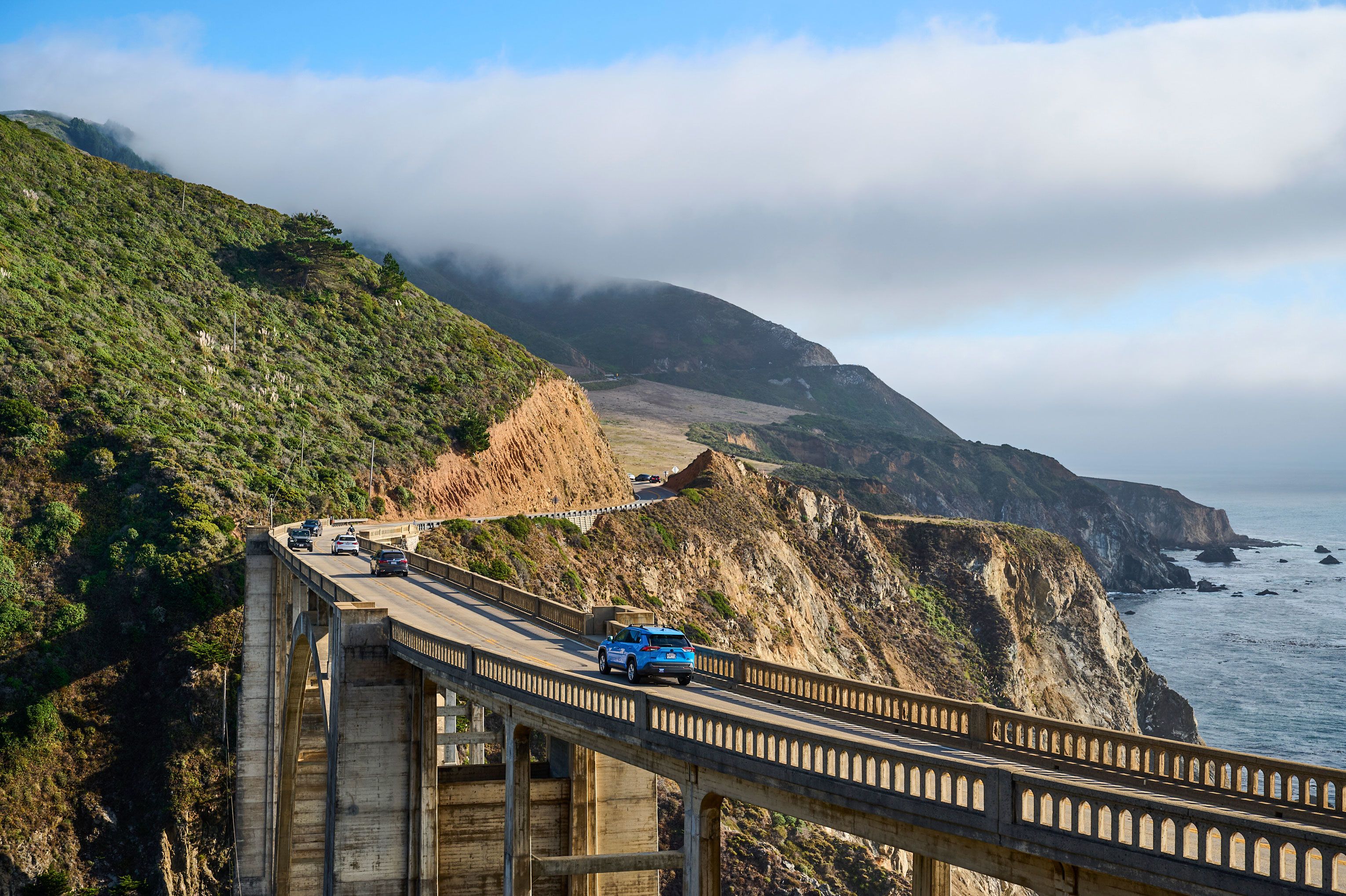
The notion of taking “the perfect road trip” is one of near legend, but so is the only state you can really have one in. California, by way of the Pacific Coast Highway, is dizzying in its proportions, with the narrow, winding ribbon of road flanked by long beaches and cliffs on one side, and mountains and giant old-growth forest on the other. The landscape is almost too big, too cinematic to process. The nearly 100-year-old route accommodates all budgets and travel interests, an à la carte menu of nature, food, history and recreation. You could have a literary-themed coastal trip as easily as one guided by architecture or birding, surfing, hiking, shopping or wine. But the edge of the nation also courts natural disasters, including mudslides, earthquakes and wildfires. My 300-plus-mile itinerary between Los Angeles and San Francisco dipped in and out of these motifs, with surprises along the way. A road trip along the PCH’s State Route 1 needs planning but also rewards surrendering to serendipity, which is how I unexpectedly began my adventure in Johnny Cash’s bedroom. A Ring of Fire: Casitas Springs to Santa Barbara Some trips end with a pilgrimage site; this trip began with one. In the late 1950s, Johnny and Vivian Cash, his first wife, along with their three daughters, moved from Memphis, Tennessee to California as the fabled singer sniffed out a potential career in Hollywood, like his contemporary Elvis Presley. The Cash family eventually settled more than 70 miles from LA, in the working-class town of Casitas Springs, between Ojai and seaside Ventura. They designed their own version of Graceland, a mid-century-modern ranch house overlooking the valley. “My little piece of heaven,” the Man in Black called it. I learned of the Johnny Cash Mountain Ranch the morning I set out north from LA, from a friend I stopped to visit on my way out of town. A few hours later I was getting a personal tour from the ranch house’s new owner, Lisa Kenton, who bought it with her husband, Jerry. They have since worked to restore the details that match when the Cashes lived there, while also adding memorabilia. As we walked from Johnny’s office to the bedrooms, by way of a sunken living room featuring Vivian’s wagon-wheel chandeliers, Lisa called out, “Alexa, play Johnny Cash.” “Walk the Line” blared as I stepped into the main bedroom. According to a plaque on the house, before it was built Johnny laid down in the dirt and declared, “I want my bed right here.” You can tour the house (the website advertises open days, or larger groups can arrange them), but unlike Graceland you can book a stay in the Cash home, cook on their barbecue deck, swim in their pool and lounge at the poolside bar that was converted from the girls’ playhouse. Hell, you can even write a song there. It only opened to the public two years ago so you might be the first to do that since Cash himself. As I drove north along the PCH and took in the driftwood sculptures erected on surfing beaches, I played my favorite Cash song, “Ring of Fire” (written on nearby Casitas Lake according to Vivian’s autobiography). My next stop was Montecito’s Hot Springs Canyon Trailhead, near Santa Barbara, and its ring of fire of a hike. These natural creek-fed hot springs are among the last in the country accessible and free to anyone — you just need to hike a challenging 1.3 miles into the Los Padres National Forest. Only a few others were at the springs — a cascade of cloudy blue pools as big as hot tubs. As I approached the highest one, a friendly surfer-type in his 60s sized me up as a newcomer and tipped me off that it was the hottest, nearly scalding. A mid-level pool was 7 feet long and a foot deep, the temperature Goldilocks perfect. I soaked until it eased my muscles and boosted my already good mood. I returned to the parking lot just as the sun set and raced to La Playa Azul Café in Santa Barbara for a burrito and margarita before it closed at 8 p.m., scoring a spot on their oasis of a patio. For dessert I walked to the locally famous McConnell’s ice cream on State Street near E. De La Guerra Street, before checking into the Leta Santa Barbara Goleta, an upscale motel with a pool and vinyl shop, owned by Hilton. Water World: Santa Barbara to San Luis Obispo At Santa Barbara Harbor, the outdoor seating area of Dart Coffee lies between the city’s maritime museum and a bright orange, 1960s-era Purisima diving bell. Based on overheard conversations of early-morning customers, many slept the night on their boats. Later, before checking out of my room, I took a cooling dip in the pool. The day’s elemental theme was water. Nojoqui Falls Park is located on a small road off Highway 101 between Santa Barbara and San Luis Obispo, but there’s no sign for the turnoff. A short, pleasant trail along a pretty creek takes hikers to the foot of the 80-foot-high craggy waterfall. Due to the dry conditions leading to the coastal fires farther north, the waterfall was far from raging, but it meant I could easily cup it in my hands for a delicious drink. Just beyond the college town of San Luis Obispo, locally referred to as SLO (pronounced “slow”), lies the postcard-perfect state park of Montaña de Oro, where the scent of eucalyptus trees gives way to ocean breezes on the drive to the start of a bluff trail. The park gets its golden name from wild mustard and California poppies that bloom on its hillsides in the spring, but I settled for the bright blue waters and waves crashing against rocks and cliffs. The park’s Spooner’s Cove, named after a family that once resided here, was another gathering spot. A group of teen trail runners cooled down by swimming in the freezing waters beyond its beach. I only allowed my feet to get numb in the small waves. Nearby, in the laid-back twin towns of Los Osos and Baywood, the Sweet Springs Nature Preserve skirts Morro Bay. Other visitors to the preserve included bay turtles, blue herons and a snowy white egret, with kayakers paddling behind them in the bay. The spot is also something of a natural watering hole between the all-porch hangout of Beerwood, and the wood-walled dive bar Niffy’s Merrimaker (locally known as the Marriage Breaker). But the best view was from the rooftop bar at the Hotel San Luis Obispo where I watched the late sunlight dim against the local volcanoes-turned-mountains surrounding the town. Made in California: San Luis Obispo to San Simeon The original Cal Poly university campus there gives San Luis Obispo a youthful energy. The small park in front of the adobe-looking Mission San Luis Obispo de Tolosa was packed on a Friday night with an all-ages crowd listening to live music. The mission, founded in 1772, is one of 21 in California. The road connecting them (and the towns between San Diego and Monterey) was known as El Camino Real. It was also the setting for the fictional adventures of Zorro, a swashbuckling hero serialized in films and books by Johnston McCulley starting in 1919. Today, El Camino Real is largely Highway 101, running parallel to, and at times overlapping with, Route 1. Other architectural highlights of SLO included a walkthrough of the garish and ornate Madonna Inn, a Disneyland-esque hotel and restaurant. Three miles north on the 101 lies the abandoned sign and main building of the former Milestone Mo-Tel, the first motel in America, which opened in 1925 and closed in 1991. At Cal Poly, there’s a unique park of public architecture structures called the Experimental Practices Laboratory where you hike from one imaginative student legacy project to another, up and down the hills. The most popular sandwich shop in town is, deservedly, the headquarters location of High Street Market and Deli. The Green Bottle bar and beer garden there was a lively spot to hang out in while I waited an hour as they worked through a queue of hungry patrons, for my perfect, stacked garden burger. My next stop was Cayucos, another popular beach town with a pier, this one with a view of the iconic Morro Rock, likewise jutting into the ocean. I scored a stool at the popular upstairs bar at Schooners where sea breezes rolled in through the open windows. Then it was on to the towns of Cambria and San Simeon, where I began retracing my steps from Cali road trips past, which largely demonstrated how little has changed in the area over the last 25 years. The Piedras Blancas Elephant Seal Rookery (7 miles north of San Simeon) remains full of massive, delightfully noisy beasts. They’re protected from sharks by all the kelp growth in that spot, explained a volunteer docent who also shared that the beach’s live cam gets rather steamy in January. Twenty-five years earlier I’d also visited San Simeon’s Hearst Castle, bespoke home of media mogul William Randolph Hearst, now more famous for his fictionalized portrayal in Orson Wells’ “Citizen Kane.” It’s a stunningly beautiful, if ostentatious, display of architecture, especially in contrast to an otherwise undeveloped region of the coast — yet I was surprised to see the parking lot packed. Sure, Hearst was once Elon Musk-famous, but he died 75 years ago. Luckily for all the visitors, the castle was later donated to the state to keep its legacy intact. The farthest north I’d reach that day was the stunning 150-foot-high Ragged Point, 15 miles beyond San Simeon. A challenging trail takes you to a mashup of rocks and waves at the bottom. At the top, next to the Ragged Point Inn, stands a wooden ring sculpture called “Portal to Big Sur,” and through it you can see miles ahead — miles that would remain inaccessible during this trip. Just a mile or so north of Ragged Point on Route 1 a closed road sign and police car behind it turned me around. Two uncontained wildfires near the coast had been causing evacuations and business closings in the weeks and days ahead of my visit. Only a few days earlier, I received a call canceling my yurt reservation at the Big Sur glamping spot Treebones. Instead, I doubled back to the San Simeon Lodge motel. It was clean and comfortable but no Hearst Castle or even Treebones yurt. Into the Fire: Cambria to Big Sur Due to the closing of 30 or so miles of the PCH, I had to drive south and connect with the 101 north in order to go around the fires, and back out to the coast and down to Big Sur that day. It was a 190-mile backwards ‘C’-shaped detour. My personal ring of fire. But first, I parked in the middle of Cambria, a charming strip of a town, for olallieberry pie for breakfast. Linn’s, decorated with vintage bikes mounted along its high walls, lived up to the hype. My slice was an alchemy of crust and rich berry, somewhere in the blue to blackberry spectrum. Linn’s also uses it for cream puffs, muffins, milkshakes and tea, but “pie is our why” read my coffee mug with their slogan on it. On my detour along the 101 I took in the mountains in the distance and farmland in between. Workers were picking the rows of vegetables or wine grapes, recalling John Steinbeck’s “The Grapes of Wrath,” one of two books I reread for this California adventure. I was, as Steinbeck wrote in it, “going to California really to go home again,” meaning it was one of those destinations you visited for the purpose of going back home to tell people about. Bragging. Once I circled back to the coast I decided to give Monterey, and later Santa Cruz, the short shrift. While they have their histories, charms and attractions (a world-class aquarium in the former, and vampires in the latter, according to the 1987 film “The Lost Boys”), I prioritized small towns and big nature instead. Of all the beautiful hikes I enjoyed on this trip, the most breathtaking was in Point Lobos State Natural Reserve, less than 4 miles south of the boutique-y Carmel-by-the-Sea, where Clint Eastwood was once mayor. The eponymous trees of the Cypress Grove Trail framed pelicans flying in formation at eye level, above clear turquoise ocean waters crashing against jagged sea walls. Everyone I heard, as they rounded the trail to the northern tip, uttered a variation of “Oooh!” or “Wow!” It was another sunny day with no visible smoke, but smaller roads and state parks were closed for emergency vehicles. Handmade signs thanked the firefighters as I entered the Big Sur region. Just after crossing the oft-photographed Bixby Bridge, a California Highway Patrol officer was writing out tickets to those parking unsafely at the edge of Route 1 to snap their selfies with the nearly 100-year-old crossing. Having reread Jack Kerouac’s “Big Sur” just before my trip I was disappointed that, because of wildfire threats, I couldn’t take the narrow Coast Road into Bixby Canyon (called Raton Canyon in the book). I’d wanted to find the spot where the writer stayed and wrote about, a cabin belonging to his friend, poet Lawrence Ferlinghetti. It was in “Big Sur,” published in 1962, that I first heard of the legendary Nepenthe restaurant, the most famous in that area of the coast. Sixty-four years later it’s still “a beautiful clifftop restaurant with vast outdoor patio, with excellent food, excellent waiters and management, good drinks, chess tables, chairs and tables to just sit in the sun and look at the grand coast,” as Kerouac reviewed it in his book. He took some creative license by calling their signature sandwich, Ambrosia burgers, “Heavenburgers.” Nepenthe comes from the Greek meaning “no sorrow” and was an ancient Egyptian drug to induce forgetfulness, according to the menu. My sorrowless meal was enjoyed outside on the deck, 808 feet above the ocean, at sunset, on Labor Day. My server said most years that holiday is their busiest, with a 3-hour wait (they don’t take reservations). But I wasn’t lucky, I was tenacious. With a lot of Big Sur shut down and inaccessible from the south, and only days from the end of a mandatory evacuation, many visitors assumed the place was closed — even though Nepenthe kept its website updated throughout. I had the vegetarian version of the Ambrosia burger and a light and refreshing local Albariño wine by La Marea, from an extensive list of options. Just after the sun melted into the sea a deer trotted by, followed by its more nervous baby. The redwood interior of Nepenthe is beautiful as well, a large round fireplace and the bar balance each other out. That night I stayed at the historic Deetjen’s Big Sur Inn, less than a mile from Nepenthe. But before I tucked in, I strapped on a headlamp and hiked up the road behind the Inn, along a little creek and multi-story redwoods. The road twisted back for an expansive view of the coast and more stars than I’ve seen since I don’t know when. Milky Way dense. Discernible satellites. A bright Venus outshining everything. And the only sounds were crickets and waves crashing far below. Another perfect moment. Into the Sunset: Big Sur to Pescadero Deetjen’s Big Sur Inn is historically rustic. The rooms don’t have keys. Cell service, much less Wi-Fi, is not available. One of its old-world charms is the handwritten guestbooks (they call them journals) in each room. I stayed up reading mine, in Little Room. It was packed with tiny biographies, poetry, words of gratitude and drawings (especially of the sweet resident cats). One little kid used several pages to start an illustrated novel. They came for honeymoons, anniversaries, birthdays or just escapes from the real world (aided by lack of internet). Deetjen’s is on the National Register of Historic Places, one of the few spots that catered to early travelers on the old Carmel-San Simeon Highway, the first stretch of what would become Route 1. I slept deeply in a darkness and quiet rarely found in any accommodation today. Even if you don’t stay at the inn, try to book dinner or breakfast at its restaurant, which was originally built as a barn in the late 1930s by Norwegian Helmuth Deetjen himself, from local redwoods and materials reclaimed from Monterey’s famous Cannery Row (immortalized by another Steinbeck novel). Visibility driving back north was hazy with wildfire smoke that morning. I had to skip the Henry Miller Memorial Library cabin and Andrew Molera State Park, where the river meets the ocean — both closed. By the time I reached Monterey it was blue skies again. And I was making fast time because Route 1 temporarily turns into a highway until Santa Cruz. Just shy of the fun college town of Santa Cruz, I stopped for a fancy lunch at the Shadowbrook Restaurant in Capitola. The small beach town has brightly painted houses, an old train bridge, a river with homes and little shops along it. Shadowbrook’s website says “it’s not about the cable car” that you can take down to their riverside patio, but it kinda is. The Pacific Coast Highway narrowed to two lanes again and the coast resembled the giant sandcastle cliffs of Limbo, as depicted in Christopher Nolan’s “Inception.” I was in a hurry — rare for this trip — to check into my final accommodation: a hostel located on the grounds of a historic lighthouse in Pescadero called Pigeon Point. The 115-foot lighthouse was built in 1872 to keep travelers safe between Monterey and San Francisco before there was a PCH. The lighthouse itself is being restored but it has a small museum, gift shop and a hostel where you can book a private room or, for only $40 as I did, a bed in a shared room. Everyone has use of a common kitchen and living room, and Wi-Fi. Although my room had six bunks, my only roommate was a quiet man from Switzerland who was also traveling from LA to San Francisco, but by bike. He too had to make a wide detour around the fires. I was eager to check in at the earliest time because that’s also when you can book the private, outdoor, cliffside hot tub (30 minutes for $10). I knew exactly when I wanted it. Over dinner at the nearby Cascade Restaurant, I thought of how far I’d come and how it seemed much longer than what you can reach on two tanks of gas. Traveling the liminal space between the state’s most famous cities felt like I’d circumnavigated a small country. Back at the lighthouse and only minutes before sunset, I walked out on their small deck containing little more than a hot tub and 180-degree view of cliffs and ocean. As a formation of pelicans flew by only feet away and waves danced below, I sank down just as the sun did on the red-yellow horizon, a beautifully epic ending to what felt like the perfect-as-it-gets coastal California road trip of my dreams.
Topics in this story
Gathered from external sources. Rights to this text belong to whoever originally published it.