In 2011, a historian scanned Saudi Arabia on Google Earth and found vast stone traps; researchers later mapped 252 across its lava fields
Rest of World News: In a groundbreaking study, historian David Kennedy utilizes Google Earth to uncover thousands of ancient stone traps across Saudi Arabia, revealing new insights into prehistoric animal hunting techniques. This research highlights the transformative power of satellite imagery in archaeology and the vast hidden landscapes of the Arabian Peninsula.
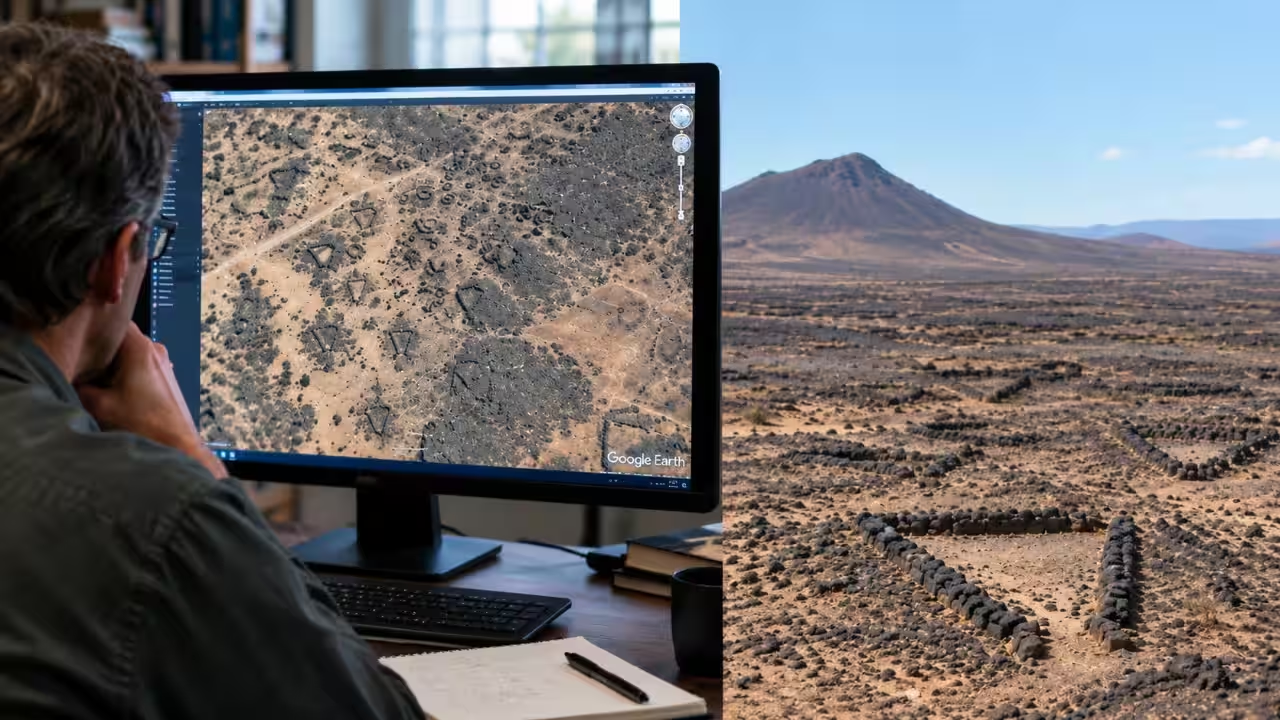
In 2011, historian David Kennedy turned to one of archaeology's least explored landscapes: Saudi Arabia. Using high-resolution imagery on Google Earth, he began examining stretches of desert that were difficult for archaeologists to survey from the ground. The satellite images revealed an extraordinary archaeological landscape: stone structures that were barely visible at ground level but strikingly clear from above. Among them were enormous formations that appeared to have been built to channel animals across the desert.According to research published in the Journal of Archaeological Science, Kennedy and archaeologist M.C. Bishop examined an area east of Jeddah in 2011 and showed that Google Earth could reveal large numbers of previously undocumented archaeological remains in Saudi Arabia. Many of these structures were thought to date back several thousand years, demonstrating how satellite imagery could help researchers identify archaeological sites across landscapes that were difficult to investigate on the ground.An archaeological landscape hiding in plain sightSaudi Arabia's enormous size had long presented a practical problem for archaeologists. The country covers about 2.15 million square kilometres, yet large areas had received relatively little systematic archaeological investigation. Ground surveys could reveal individual sites, but they could not easily show how structures were distributed across vast stretches of desert.Google Earth revolutionised that scenario. The high-resolution images captured by satellites provided archaeologists the ability to look down at large regions of land and detect patterns that were impossible to discern while being amid the stones. The 2011 study conducted by Kennedy and Bishop found 1,977 archaeological structures located in a high-resolution region to the east of Jeddah. These forms included stone circles, cairns and a structure known as pendants. What was interesting about these archaeological sites was that many of them were made up of the black basalt that is found in western Saudi Arabia.Among the most interesting structures were the so-called “desert kites.” When viewed from the air, the shapes of some can look like the shape of a child’s kite, hence the name for such constructions. The design of such buildings usually features long walls of stones, which merge and lead to an enclosed place. It is believed that these constructions served as traps for wild animals.Thousands spread across ancient lava fieldsAccording to research published in Quaternary International, the 2011 discovery was followed by wider surveys as high-resolution satellite imagery made it possible to examine larger areas of Saudi Arabia. Using Google Earth, researchers identified 252 desert kites in the country, including 207 in the Harrat Khaybar lava field and 45 in northern Saudi Arabia. The structures varied considerably in their designs, with those found at Harrat Khaybar described as distinctive “barbed” kites. The findings showed that these stone hunting structures were spread across a much larger area of the Arabian Peninsula than earlier ground surveys had suggested.The scale of the discoveries helped researchers better understand these structures. The lava fields, known as harrat, contain many rocks and boulders that could easily be incorporated into the hunting structures. The guiding walls for some kites stretch over kilometres before meeting the enclosure area. From the ground, they can look like scattered stones, but from the sky their design becomes clear. By 2014, David Kennedy and colleagues had described a rapidly growing number of kites discovered in Saudi Arabia. It was highlighted in their study that just a dozen kites were found in Saudi Arabia a generation ago, but satellite images enabled scholars to locate many more of them. Just within the Harrat Khaybar region, the numbers started increasing at a very fast pace as more and more high-resolution images started becoming available. More importantly, these discoveries suggested a broader prehistoric pattern across the Middle East.What the stone traps reveal about the pastDesert kites raise questions about why prehistoric populations invested so much effort in constructing such massive stone formations in seemingly empty landscapes. Being so large indicates that they were built according to the movement of the animals rather than to hunt individuals. They could have used long walls as barriers and guides, leading the animals into an enclosure or restricting access through a narrow pathway. The techniques must have been different from region to region.The research also showed how satellite imagery can transform archaeological survey work. The findings by Kennedy in 2011 do not indicate that Google Earth could be used as a replacement for conducting fieldwork. It shows that satellite images can be used to detect sites, map their distribution and decide where further analysis should be conducted. In subsequent years, it has been found that the use of this technique uncovers an archaeological landscape much bigger than expected.The black volcanic landscape, which can look empty at first glance, actually contains thousands of stone structures. It was not merely a matter of locating walls of the past, but rather how modern mapping technology could detect evidence of human presence that was established thousands of years ago, enabling scientists to study the scope and organisation of the ancient terrain from distances of hundreds or even thousands of kilometres.Catch the latest World News and Live updates. Download the TOI app.
Topics in this story
Gathered from external sources. Rights to this text belong to whoever originally published it.