Water rescues, evacuations underway as ‘catastrophic flood event’ hits North Georgia and southern Tennessee
Catastrophic flooding is in progress as waterways burst their banks.
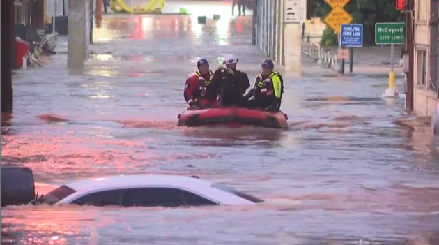
Homes and businesses are flooded, and water rescues and evacuations are in progress, as historic flooding impacts North Georgia and southern Tennessee. ⛈️☔️Get your forecast and track the storm in the CNN Weather app Flash flood emergencies — the highest level of flood warning — were issued Thursday morning for McCaysville, Georgia, in Fannin County, and Copperhill, Tennessee, in Polk County, on the Georgia-Tennessee border. Record flooding struck there along a river known as the Toccoa River in Georgia and the Ocoee River in Tennessee once it flows across the border. The river crested just above the previous record flood set in 1990 just after 6:00 a.m. ET in McCaysville and Copperhill, above the level that causes a “catastrophic flood event” in the two towns, according to the National Weather Service. The river has fallen several feet since then, but remained above flood stage as of late Thursday morning. Georgia Gov. Brian Kemp said the state is leading a multi-agency response to the flooding, including “aviation and boat assets, as well as local counties and Tennessee first responders.” Emergency management in Fannin and Gilmer counties in Georgia have reported “multiple homes flooded and some completely surrounded by water” and water rescues. A state of emergency has been issued in McCaysville, and the city is closed until further notice, according to the city’s police chief Michael Earley. “We’re actively trying to water rescue people, and we’ve still got several people trapped in homes that we’re trying to get to,” Earley told CNN affiliate Atlanta News First. Evacuations were ordered for residents in McCaysville on West Tennessee Avenue and East Tennessee Avenue, where a Georgia DOT camera showed streets and buildings swamped by the flooded river. There were still “numerous residents” that needed evacuations in Fannin County, the county’s emergency management said early Thursday morning. Crews have been conducting rescues “all night long” the county Fire Chief Larry Thomas told CNN. At least two cars were swept away by floodwater, but their occupants were rescued uninjured, he said. On Thursday morning, crews were conducting a rescue at a home that had standing water up to the countertops, he added. Multiple roads are blocked by mudslides or have been washed away completely, and propane tanks have become dislodged and are floating in floodwater, according to Thomas. At least one propane tank was on fire in McCaysville, CNN affiliate WSB-TV reported. There were also at least four structure fires overnight, which Thomas believes were caused by lightning. Two of the structures, one a home, were lost after floodwater prevented fire trucks from responding. A separate flash flood emergency was also issued overnight for other parts of Fannin County and neighboring Gilmer County in Georgia. Water has also entered homes in Gilmer County, with knee-deep water covering roads in impacted residential areas, Aaron Freeman, the county emergency management director, told CNN Thursday morning. Crews rescued three people stranded in two houses, he said, and flooding has also cut off access to a small group of homes, but residents there have not reported any issues. Widespread rainfall totals of 3 to 6 inches from slow-moving overnight storms were reported across parts of North Georgia, with over 8 inches in isolated spots. Up to 6 inches of rain fell in just six hours at multiple rain gauges in the area. This equates to at least a 1-in-200-year rainfall — a rate that has only a 0.5% chance of happening in a given year, under normal circumstances. Such extreme rainfall is becoming more common as planet-warming pollution pushes temperatures higher as warmer air can hold more moisture. The rain has come to an end across northern Georgia and southern Tennessee. No additional downpours are expected through the weekend, but dangerous river flooding will remain a threat throughout the day. East Coast next up for flood threat The wet weather will shift east and hit coastal portions of the Northeast and Mid-Atlantic Thursday night into Saturday morning, with the heaviest rain expected on Friday. Widespread and significant flooding is unlikely because the ground is primed to soak up most of the rain after weeks of dryness. But some flooding could unfold if enough rain falls too fast. A Level 2 of 4 risk of flooding rain is in place for southern New England, where the brunt of the heaviest rain is forecast. Totals of 1 to 3 inches are expected there, but a few locations caught under repeated heavy downpours could deal with closer to 5 inches. It’s difficult to pinpoint exactly where that could occur until the storms are underway. Boston is just outside of this zone in a broader Level 1 of 4 flood threat in New England. Flooding is most likely in urban and low-lying areas that are less capable of handling heavy rain. In the Mid-Atlantic, a Level 1 of 4 risk of flooding rainfall is in place Friday in southeastern Virginia and northeastern North Carolina. There’s currently no outlooked flood threat along the Interstate 95 corridor from New York City to Washington, DC, but rain is likely there — especially very late Thursday night through Friday morning. Ponding on roadways and delays at area airports are possible. Most of the East Coast will dry out by Saturday afternoon, but some showers could develop deeper inland.
Topics in this story
Gathered from external sources. Rights to this text belong to whoever originally published it.